
The variety of different orbits that can be adopted for satellites. The ones that receive the most attention are the geostationary orbit used by many communications and direct broadcast satellites for satellite television and also the low earth orbit ones that travel around the global. Those used in the Navstar or Global Positioning (GPS) system occupy a relatively low earth orbit. There are also many other types of satellite from weather satellites to research satellites and many others.
The actual orbit that is chosen will depend on factors including its function, and the area it is to serve. In some instances the orbit may be as low as 100 miles (160 km) for a low earth orbit (LEO), whereas others may be over 22 000 miles (36000 km) high as in the case of a geostationary orbit. The satellite may even have an elliptical rather than a circular orbit.
Gravity
As satellites orbit the earth they are pulled back in by the force of the gravitational field. If they did not have any motion of their own they would fall back to earth, burning up in the upper reaches of the atmosphere. Instead the motion of the satellite rotating around the earth has a force associated with it pushing it away from the earth. For any given orbit there is a speed for which gravity and the centrifugal force balance each other and the satellite remains in a stable orbit, neither gaining height nor loosing it.
Obviously the lower the orbit, the stronger the gravitational pull, and this means that the satellite must orbit the earth faster to counteract this pull. Further away the gravitational field is less and the satellite velocities are correspondingly less. For a very low orbit of around 100 miles a velocity of about 17500 miles per hour is needed and this means that the satellite will orbit the earth in about 90 minutes. At an altitude of 22 000 miles a velocity of just less than 7000 miles per hour is needed giving an orbit time of about 24 hours.
Circular and elliptical orbits
A satellite can orbit the earth in one of two basic types of orbit. The most obvious is a circular orbit where the distance from the earth remains the same at all times. A second type of satellite orbit is an elliptical one.
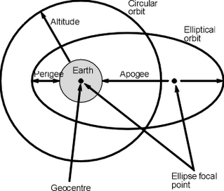
When a satellite orbits the earth, either in a circular or elliptical orbit, the satellite orbit forms a plane that passes through the centre of gravity or geocentre of the Earth. The rotation around the earth is also categorised. It may be in the same direction as the earth's rotation when it is said to be posigrade, or it may be in the opposite direction when it is retrograde.
The track of the satellite around the globe is often defined as well. The point on the Earth's surface where the satellite is directly overhead moves around the globe. This is known as the ground track. This forms a circle which has the geocentre at its centre. It is worth noting that geostationary satellites are a special case as they appear directly over the same point of the earth all the time. This means that their ground track consists of a single point on the earth's equator. Also for satellites with equatorial orbits the ground track is along the equator.
Satellites may also be in other orbits. These will cross the equator twice, once in a northerly direction, and once in a southerly direction. The point at which the groundtrack crosses the equator is known as a node. There are two, and the one where the groundtrack passes from the southern hemisphere to the northern hemisphere is called the ascending node. The one where the groundtrack passes from the northern to the southern hemisphere is called the descending node. For these orbits it is usually found that the groundtrack shifts towards the west for each orbit because the earth is rotating towards the east underneath the satellite.
For many orbit calculations it is necessary to consider the height of the satellite above the geocentre. This is the height above the earth plus the radius of the earth. This is generally taken to be 3960 miles or 6370 km.
Velocity is another important factor as already seen. For a circular orbit it is always the same. However in the case of an elliptical one this is not the case as the speed changes dependent upon the position in the orbit. It reaches a maximum when it is closest to the earth and it has to combat the greatest gravitational pull, and it is at its lowest speed when it is furthest away.
Elliptical orbits are often used, particularly for satellites that only need to cover a portion of the Earth's surface. For any ellipse, there are two focal points, and one of these is the geocentre of the Earth. Another feature of an elliptical orbit is that there are two other major points. One is where the satellite is furthest from the Earth. This point is known as the apogee. The point where it is closest to the Earth is known as the perigee.
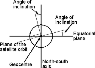
The plane of a satellite orbit is also important. Some may orbit around the equator, whereas others may have different orbits. The angle of inclination of a satellite orbit is shown in Figure 8.2. It is the angle between a line perpendicular to the plane of the orbit and a line passing through the poles. This means that an orbit directly above the equator will have an inclination of 0 degrees (or 180 degrees), and one passing over the poles will have an angle of 90 degrees. Those orbits above the equator are generally called equatorial obits, whilst those above the poles are called polar orbits.
A further feature of any satellite is the angle of elevation above the Earth's surface at a given position on the Earth and a given time. It is very important because the earth station will only be able to maintain contact with the satellite when it is visible. The angle of elevation is the angle at which the satellite appears above the horizontal. If the angle is too small then signals may be obstructed by nearby objects if the antenna is not very high. For those antennas that have an unobstructed view there are still problems with small angles of elevation. The reason is that signals have to travel through more of the earth's atmosphere and are subjected to higher levels of attenuation as a result. An angle of five degrees is generally accepted as the minimum angle for satisfactory operation.
In order that a satellite can be used for communications purposes the ground station must be able to follow it in order to receive its signal, and transmit back to it. Communications will naturally only be possible when it is visible, and dependent upon the orbit it may only be visible for a short period of time. To ensure that communication is possible for the maximum amount of time there are a number of options that can be employed. The first is to use an elliptical orbit where the apogee is above the planned earth station so that the satellite remains visible for the maximum amount of time. Another option is to launch a number of satellites with the same orbit so that when one disappears from view, and communications are lost, another one appears. Generally three satellites are required to maintain almost uninterrupted communication. However the handover from one satellite to the next introduces additional complexity into the system, as well as having a requirement for at least three satellites.
Circular orbits
Circular orbits are classified in a number of ways. Terms such as Low Earth orbit, Geostationary orbit and the like detail distinctive elements of the orbit:
* Low Earth Orbit (LEO: 200 - 1200km above the Earth's surface)
* Medium Earth Orbit (MEO or ICO: 1200 - 35790 km)
* Geosynchronous Orbit (GEO: 35790 km above Earth's surface)
* Geostationary Orbit (GSO)
* High Earth Orbit (HEO: above 35790 km)
The LEO and MEO are used for many types of satellite. As they are relatively close to the Earth's surface they orbit in times much shorter than those higher up. This is because there is a particular velocity required at any given altitude for the gravitational and centrifugal forces to balance. Also the path loss to and from the satellite is much lower in view of the shorter radio paths involved.
As the height of a satellite increases, so the time for the satellite to orbit increases. At a height of 35790 km, it takes 24 hours for the satellite to orbit. This type of orbit is known as a geosynchronous orbit, i.e. it is synchronized with the Earth.
One particular form of geosynchronous orbit is known as a geostationary orbit. In this type of orbit the satellite rotates in the same direction as the rotation of the earth and has a 24 hour period. This means that it revolves at the same angular velocity as the earth and in the same direction and therefore remains in the same position relative to the earth. Geostationary orbits are very popular because once the earth station is set onto the satellite it can remain in the same position, and no tracking is normally necessary. This considerably simplifies the design and construction of the antenna. For direct broadcast satellites it means that people with dishes outside the home do not need to adjust them once they have been directed towards the satellite.
Once in a geostationary orbit, the satellite needs to be kept in its position and not drift. Small rockets are installed on a satellite to ensure that any deviations can be corrected.
The path length to any geostationary satellite is a minimum of 22300 miles. This gives a small but significant delay of 0.24 seconds. For a communications satellite this must be doubled to account for the uplink and downlink times giving virtually half a second. This delay can make telephone conversations rather difficult when satellite links are used. It can also be seen when news reporters as using satellite links. When asked a question from the broadcasters studio, the reporter appears to take some time to answer. This delay is the reason why may long distance links use cables rather than satellites as the delays incurred are far less.
In some applications high earth orbits may be required. For these applications the satellite will take longer than 24 hours to orbit the Earth, and path lengths may become very long resulting in additional delays for the round trip from the Earth toth e satellite and back as well as increasing the levels of path loss.
The choice of the satellite orbit will depend on its applications. While geostationary orbits are popular for applications such as direct broadcasting and for communications satellites, others such as GPS and even those satellites used for mobile phones are much lower.
The actual orbit that is chosen will depend on factors including its function, and the area it is to serve. In some instances the orbit may be as low as 100 miles (160 km) for a low earth orbit (LEO), whereas others may be over 22 000 miles (36000 km) high as in the case of a geostationary orbit. The satellite may even have an elliptical rather than a circular orbit.
Gravity
As satellites orbit the earth they are pulled back in by the force of the gravitational field. If they did not have any motion of their own they would fall back to earth, burning up in the upper reaches of the atmosphere. Instead the motion of the satellite rotating around the earth has a force associated with it pushing it away from the earth. For any given orbit there is a speed for which gravity and the centrifugal force balance each other and the satellite remains in a stable orbit, neither gaining height nor loosing it.
Obviously the lower the orbit, the stronger the gravitational pull, and this means that the satellite must orbit the earth faster to counteract this pull. Further away the gravitational field is less and the satellite velocities are correspondingly less. For a very low orbit of around 100 miles a velocity of about 17500 miles per hour is needed and this means that the satellite will orbit the earth in about 90 minutes. At an altitude of 22 000 miles a velocity of just less than 7000 miles per hour is needed giving an orbit time of about 24 hours.
Circular and elliptical orbits
A satellite can orbit the earth in one of two basic types of orbit. The most obvious is a circular orbit where the distance from the earth remains the same at all times. A second type of satellite orbit is an elliptical one.

When a satellite orbits the earth, either in a circular or elliptical orbit, the satellite orbit forms a plane that passes through the centre of gravity or geocentre of the Earth. The rotation around the earth is also categorised. It may be in the same direction as the earth's rotation when it is said to be posigrade, or it may be in the opposite direction when it is retrograde.
The track of the satellite around the globe is often defined as well. The point on the Earth's surface where the satellite is directly overhead moves around the globe. This is known as the ground track. This forms a circle which has the geocentre at its centre. It is worth noting that geostationary satellites are a special case as they appear directly over the same point of the earth all the time. This means that their ground track consists of a single point on the earth's equator. Also for satellites with equatorial orbits the ground track is along the equator.
Satellites may also be in other orbits. These will cross the equator twice, once in a northerly direction, and once in a southerly direction. The point at which the groundtrack crosses the equator is known as a node. There are two, and the one where the groundtrack passes from the southern hemisphere to the northern hemisphere is called the ascending node. The one where the groundtrack passes from the northern to the southern hemisphere is called the descending node. For these orbits it is usually found that the groundtrack shifts towards the west for each orbit because the earth is rotating towards the east underneath the satellite.
For many orbit calculations it is necessary to consider the height of the satellite above the geocentre. This is the height above the earth plus the radius of the earth. This is generally taken to be 3960 miles or 6370 km.
Velocity is another important factor as already seen. For a circular orbit it is always the same. However in the case of an elliptical one this is not the case as the speed changes dependent upon the position in the orbit. It reaches a maximum when it is closest to the earth and it has to combat the greatest gravitational pull, and it is at its lowest speed when it is furthest away.
Elliptical orbits are often used, particularly for satellites that only need to cover a portion of the Earth's surface. For any ellipse, there are two focal points, and one of these is the geocentre of the Earth. Another feature of an elliptical orbit is that there are two other major points. One is where the satellite is furthest from the Earth. This point is known as the apogee. The point where it is closest to the Earth is known as the perigee.
The plane of a satellite orbit is also important. Some may orbit around the equator, whereas others may have different orbits. The angle of inclination of a satellite orbit is shown in Figure 8.2. It is the angle between a line perpendicular to the plane of the orbit and a line passing through the poles. This means that an orbit directly above the equator will have an inclination of 0 degrees (or 180 degrees), and one passing over the poles will have an angle of 90 degrees. Those orbits above the equator are generally called equatorial obits, whilst those above the poles are called polar orbits.
A further feature of any satellite is the angle of elevation above the Earth's surface at a given position on the Earth and a given time. It is very important because the earth station will only be able to maintain contact with the satellite when it is visible. The angle of elevation is the angle at which the satellite appears above the horizontal. If the angle is too small then signals may be obstructed by nearby objects if the antenna is not very high. For those antennas that have an unobstructed view there are still problems with small angles of elevation. The reason is that signals have to travel through more of the earth's atmosphere and are subjected to higher levels of attenuation as a result. An angle of five degrees is generally accepted as the minimum angle for satisfactory operation.
In order that a satellite can be used for communications purposes the ground station must be able to follow it in order to receive its signal, and transmit back to it. Communications will naturally only be possible when it is visible, and dependent upon the orbit it may only be visible for a short period of time. To ensure that communication is possible for the maximum amount of time there are a number of options that can be employed. The first is to use an elliptical orbit where the apogee is above the planned earth station so that the satellite remains visible for the maximum amount of time. Another option is to launch a number of satellites with the same orbit so that when one disappears from view, and communications are lost, another one appears. Generally three satellites are required to maintain almost uninterrupted communication. However the handover from one satellite to the next introduces additional complexity into the system, as well as having a requirement for at least three satellites.
Circular orbits
Circular orbits are classified in a number of ways. Terms such as Low Earth orbit, Geostationary orbit and the like detail distinctive elements of the orbit:
* Low Earth Orbit (LEO: 200 - 1200km above the Earth's surface)
* Medium Earth Orbit (MEO or ICO: 1200 - 35790 km)
* Geosynchronous Orbit (GEO: 35790 km above Earth's surface)
* Geostationary Orbit (GSO)
* High Earth Orbit (HEO: above 35790 km)
The LEO and MEO are used for many types of satellite. As they are relatively close to the Earth's surface they orbit in times much shorter than those higher up. This is because there is a particular velocity required at any given altitude for the gravitational and centrifugal forces to balance. Also the path loss to and from the satellite is much lower in view of the shorter radio paths involved.
As the height of a satellite increases, so the time for the satellite to orbit increases. At a height of 35790 km, it takes 24 hours for the satellite to orbit. This type of orbit is known as a geosynchronous orbit, i.e. it is synchronized with the Earth.
One particular form of geosynchronous orbit is known as a geostationary orbit. In this type of orbit the satellite rotates in the same direction as the rotation of the earth and has a 24 hour period. This means that it revolves at the same angular velocity as the earth and in the same direction and therefore remains in the same position relative to the earth. Geostationary orbits are very popular because once the earth station is set onto the satellite it can remain in the same position, and no tracking is normally necessary. This considerably simplifies the design and construction of the antenna. For direct broadcast satellites it means that people with dishes outside the home do not need to adjust them once they have been directed towards the satellite.
Once in a geostationary orbit, the satellite needs to be kept in its position and not drift. Small rockets are installed on a satellite to ensure that any deviations can be corrected.
The path length to any geostationary satellite is a minimum of 22300 miles. This gives a small but significant delay of 0.24 seconds. For a communications satellite this must be doubled to account for the uplink and downlink times giving virtually half a second. This delay can make telephone conversations rather difficult when satellite links are used. It can also be seen when news reporters as using satellite links. When asked a question from the broadcasters studio, the reporter appears to take some time to answer. This delay is the reason why may long distance links use cables rather than satellites as the delays incurred are far less.
In some applications high earth orbits may be required. For these applications the satellite will take longer than 24 hours to orbit the Earth, and path lengths may become very long resulting in additional delays for the round trip from the Earth toth e satellite and back as well as increasing the levels of path loss.
The choice of the satellite orbit will depend on its applications. While geostationary orbits are popular for applications such as direct broadcasting and for communications satellites, others such as GPS and even those satellites used for mobile phones are much lower.


0 Comments:
<< Home | << Add a comment